
Follow Us
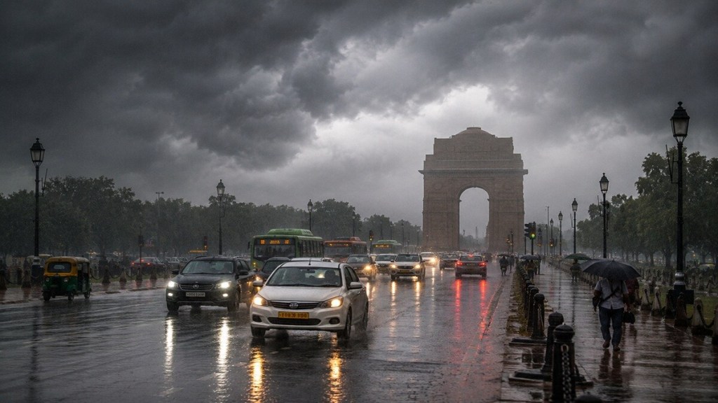
Monsoon Tracker: Delhi-NCR, already in rainfall surplus for August, is likely to remain cloudy on August 26 with light rain or drizzle at some places, while isolated thunderstorms and short showers may still affect parts of Delhi, Noida, Gurugram, Ghaziabad and adjoining areas.
The IMD-based outlook suggests rainfall will be uneven across the NCR, with a gradual easing in activity after the current spell; temperatures may remain near 33-34°C during the day.
“Delhi-NCR is already sitting on a rainfall surplus this month. August has logged 200.7 mm against a normal of 156.4 mm, a 28 per cent surplus, and the season overall is running 7 per cent above normal at 436.6 mm,” said K Venkatramana, Fellow and Area Convener at the Center for Climate Modelling in TERI’s Earth Science and Climate Change Division to Financial Express online.
Suruchi Bhadwal, Director of The Energy and Resources Institute (TERI), said the concern is not only surplus rainfall but the increasingly intense manner in which it is falling.
“Any amount of rainfall now predicted in August is a surplus. The issue is also with the rainfall coming in extreme forms, with a high amount of rain restricted in a few hours,” she said to Financial Express online.
The broader heavy-rain threat, however, remains concentrated over Chhattisgarh, MP, Jharkhand and Odisha, where a low-pressure area embedded in the monsoon trough continues to draw moisture inland. Venkatramana said the system is unlikely to develop into a larger storm because it is moving away from warm ocean waters and over land, though it can still bring heavy rain for the next two to three days.
Brief rain spell to ease, Delhi temperatures set to rise before showers return
In Delhi-NCR, light rain or drizzle may continue on August 26 and 27 as the weather system moves away from the region. From August 28 to 29, skies are likely to clear, and daytime temperatures could rise to 35-37°C. Rain is expected to return briefly on August 30 and 31, potentially adding to Delhi’s already significant August surplus.
Venkatramana said the national capital has received above-normal rainfall in both July and August.
“Litle more rain is expected on 30-31 Aug too, adding further to that surplus,” he said. “From August the warning goes away, but it will still drizzle lightly on 26th and 27th. From Aug 28-29, no rain at all, clear skies, and it gets hotter, up to 35-37°C.”
Suruchi Bhadwal said the pattern of short, intense downpours is particularly important for Delhi-NCR, where heavy rainfall concentrated within a few hours can overwhelm drainage even when seasonal rainfall totals alone do not appear exceptional.
ALSO READEl Nino strengthens as India’s monsoon faces 15% deficit: Which crops face risk
Low-pressure area shifts heavy rain westward
The India Meteorological Department (IMD) has forecast heavy to very heavy rainfall across central and eastern India as a low-pressure area over Gangetic West Bengal and adjoining Jharkhand and north Odisha moves nearly northwestwards.
The weather system is expected to increase rainfall over Jharkhand, Chhattisgarh, Madhya Pradesh, and nearby areas. The IMD has forecast heavy to very heavy rain over Odisha and Jharkhand, Chhattisgarh, and both east and west Madhya Pradesh during the current spell. Bihar and Uttar Pradesh may also receive isolated heavy rainfall.
The system is supported by a monsoon trough that extends from southwest Uttar Pradesh through north Madhya Pradesh, north Chhattisgarh, and Jharkhand towards the cyclonic circulation associated with the low-pressure area. A western disturbance over northern India, an upper-air cyclonic circulation over north Haryana, another over northeast Assam, and an additional circulation over east Madhya Pradesh are also affecting weather conditions.
Venkatramana said the low-pressure area is not expected to become a more intense cyclone or storm.
“Forecast models say there’s basically zero chance of it turning into a bigger storm this week,” he said. “It’s also moving the wrong way to grow stronger; it’s heading inland, away from the sea. These systems need warm ocean water to build up. Once they move over land, they usually weaken instead.”
He said the system will nevertheless continue to produce heavy rain for the next two to three days, mainly over Chhattisgarh and Madhya Pradesh, before rainfall intensity starts easing.
Why Chhattisgarh and Madhya Pradesh may receive the heaviest rain?
Venkatramana said the monsoon trough is acting as a moisture channel linking the weather system to the Bay of Bengal.
“There’s a low pressure stretching from the hills through Jharkhand out to the Bay of Bengal; that’s the monsoon trough,” he said. “The low-pressure system sits right on it, so it stays plugged into the sea and keeps pulling in moisture, which is why Jharkhand is getting heavy rain right now.”
The interaction becomes stronger farther west because upper-air circulations over Chhattisgarh and Madhya Pradesh are helping lift moisture through a deeper layer of the atmosphere.
“A few wind circulations are also stacked above the trough further west, over Chhattisgarh and Madhya Pradesh,” Venkatramana said. “When winds line up like that, they drag moisture up through a deeper layer of air. That’s why those two states are actually getting the very heaviest rain of all, even more than Jharkhand.”
As the low-pressure area drifts westward, the zone of intense rainfall will also shift. “Bihar’s rain is easing off as the system moves away. Odisha gets wetter next. West Bengal and Sikkim stay wet all week since they’re close to the sea end of the trough,” he said.
ALSO READUttarakhand rains: NH-707A washed away in Tehri Garhwal, NH-07 blocked near Devprayag
Odisha, Jharkhand, Chhattisgarh and Madhya Pradesh on alert
Odisha and Jharkhand face the immediate risk of heavy to very heavy rain, thunderstorms, lightning, and gusty winds. Jharkhand is likely to receive fairly widespread to widespread rainfall through August 30, while Odisha could see widespread rain again from August 27 to 30.
Winds of 30-40 kmph, gusting up to 50 kmph, may affect Gangetic West Bengal, Sub-Himalayan West Bengal, Sikkim, Jharkhand, and Odisha. Strong winds could damage weak structures, uproot small trees, and affect standing crops.
Central India is likely to see the most persistent rain. West Madhya Pradesh may receive widespread rain until August 26, while east Madhya Pradesh could remain wet through August 29. Chhattisgarh is expected to see widespread rainfall until August 30, and Vidarbha may receive widespread rainfall through August 28.
The IMD has warned of isolated very heavy rain over Chhattisgarh and Madhya Pradesh, accompanied by thunderstorms and lightning. Heavy rain could affect roads, rail tracks, mining areas, agricultural fields, culverts, urban drainage networks, and low-lying settlements.
The department defines heavy rainfall as 64.5-115.5 mm in 24 hours, very heavy rainfall as 115.6-204.4 mm, and extremely heavy rainfall as more than 204.4 mm.
Flash-flood risk in vulnerable districts
The IMD’s flash-flood guidance has flagged low to moderate risk across selected watersheds and adjoining areas, particularly where soils are saturated and drainage is inadequate. In Odisha, districts identified as vulnerable include Balasore, Keonjhar, Mayurbhanj, Jajpur, Dhenkanal, Angul, Sundargarh, Jharsuguda, Deogarh, Sambalpur, Sonepur, and Bargarh.
In Chhattisgarh, the risk extends to Koriya, Surajpur, Surguja, Jashpur, Korba, Bilaspur, Raigarh, Janjgir, Baloda Bazar, Mahasamund, Mungeli, Kabirdham, and Rajnandgaon. In east Madhya Pradesh, districts including Balaghat, Dindori, Mandla, Anuppur, Katni, Shahdol, Rewa, Sidhi, Umaria, Satna, and Singrauli are vulnerable to localised flooding and runoff.
The main danger is not limited to rivers overflowing. Intense rain can quickly cause surface runoff, inundate low-lying areas, overwhelm drains, and flood roads, especially in places where the ground has already absorbed repeated spells of monsoon rain.
Infrastructure risk extends beyond waterlogging
Heavy rain is likely to disrupt road and rail movement, reduce visibility, and damage vulnerable infrastructure. Low-lying urban areas may face waterlogging, while hill districts could see landslides, mudslides, erosion, and road blockages.
Suruchi B said the effects of the monsoon have been visible since July, especially in cities. “The rains have been creating havoc since July, especially visible in urban areas, leading to traffic chaos [and] impacts on road infrastructure,” she said.
“In many cases drainage systems are choked for multiple reasons, including the downpour and lack of proper O&M, including cleaning,” she added.
The warning is particularly relevant for cities and industrial areas where intense rain can interrupt traffic, damage local roads, disrupt last-mile supply chains, and affect power distribution. Waterlogged substations, fallen branches, damaged power lines, and limited access for repair teams can compound the risk during severe thunderstorms.
Urban authorities may need to keep drainage pumps, emergency teams, and traffic-control arrangements ready. District administrations in vulnerable areas should monitor rivers, dams, culverts, low-lying settlements, and landslide-prone road stretches.
Farmers advised to prioritise drainage and storage
The weather spell comes during the Kharif season, raising the risk of waterlogging, crop lodging, and damage to horticulture and plantation crops. Farmers in Jharkhand, Odisha, Madhya Pradesh, Chhattisgarh, and Vidarbha have been advised to maintain field drainage and remove stagnant water quickly.
Fertiliser application, pesticide spraying, and intercultural operations should be postponed until rainfall reduces and fields become workable. Odisha farmers have been advised to clear field drains, outlets, and bunds in rice, maize, pulses, cotton, pigeon pea, banana, and vegetable fields. In waterlogged locations, sowing or re-sowing of maize and green gram should be deferred.
In Madhya Pradesh and Chhattisgarh, soybean, maize, cotton, sugarcane, rice, pulses, and vegetable fields need protection from prolonged water stagnation. Young vegetable plants, banana, papaya, and other horticultural crops may need staking or other support against wind and rain damage.
Suruchi B added that farmers and livestock owners should also pay attention to disease risk and safe storage.
“It’s the Kharif season. Places where rice is grown and have seen deficits are impacted,” she said. “Hot and humid climate has impacts on livestock wellbeing as they are likely to be exposed to more diseases in such environments.”
“Food storage also needs to be checked and made sure to be aerated to avoid pest infestation. It applies to all crops — wheat, maize, rice stored,” she further stated.
Livestock should be kept in dry sheds during heavy rain, while feed and fodder must be stored away from moisture. Fish ponds should have secure, netted outlets to prevent fish from escaping if water levels rise.
ALSO READTractor industry growth seen slowing to 1-4% in FY27
Rain continues elsewhere in India
Uttarakhand is likely to receive fairly widespread to widespread rainfall through August 30, with heavy rain expected on August 29 and 30. Heavy rainfall in Himalayan states could trigger landslides, mudslides, local flash floods, and road closures.
East Uttar Pradesh may receive fairly widespread to widespread rain from August 25 to 27. Isolated heavy rainfall is also likely over parts of Bihar and Uttar Pradesh. Jammu and Kashmir, Ladakh, Himachal Pradesh, and other western Himalayan areas may continue receiving scattered rainfall.
In the northeast, Arunachal Pradesh, Assam, Meghalaya, Nagaland, Manipur, Mizoram, and Tripura are expected to receive widespread rain during parts of the week. Isolated heavy rainfall and thunderstorms may continue across the region.
Western India is likely to see widespread rainfall over Konkan and Goa through August 30. Madhya Maharashtra and Marathwada may also receive heavy rain and thunderstorms, while Gujarat, Saurashtra, and Kutch are expected to see scattered rainfall.
Rainfall activity may remain comparatively subdued over much of peninsular India, although coastal Karnataka, Kerala, Lakshadweep, Tamil Nadu, Telangana, and parts of Andhra Pradesh are likely to receive rain, thunderstorms, and strong winds. Kerala could receive isolated very heavy rain, while coastal Karnataka and Tamil Nadu may also see isolated heavy spells.
Public and marine safety measures
Residents in flood-prone areas should avoid crossing flooded roads, streams, and bridges. Drivers should prepare for sudden water accumulation, low visibility, and slippery road conditions. During thunderstorms, people should avoid sheltering under trees, stay away from water bodies and electrical conductors, and unplug electrical and electronic appliances where feasible.
The IMD has also advised fishermen to avoid vulnerable stretches of the Arabian Sea and Bay of Bengal. Rough seas and strong winds may affect waters off the coasts of Karnataka, Kerala, Lakshadweep, Odisha, and north Andhra Pradesh, as well as parts of the Gulf of Mannar, Comorin area, and Andaman Sea.
The broader outlook remains one of a shifting, high-impact monsoon spell rather than a developing major storm. With the low-pressure system moving inland and westward, the immediate focus will remain on flood preparedness, drainage management, transport continuity, and crop protection across central and eastern India.
TOPICSArabian SeaDelhiEl NinoIMDIndian Ocean DipoleMonsoonMonsoon 2026Monsoon RainsSuper El NinoWeatherweather forecastWeather update + 0 MoreThis article was first uploaded on August twenty-six, twenty twenty-six, at twenty-four minutes past two in the afternoon. © IE Online Media Services (P) Ltd